28 December 2012

Bring out the Guillotines

There has been a lot of chatter about the "blown" forecast for snow the day after Christmas.  Unfortunately, it was not a blown forecast.  The feast or famine scenario was realized (described in my last post), and we experienced famine.  An image of snow totals in the area can be found below.
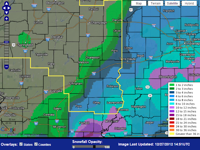


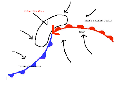
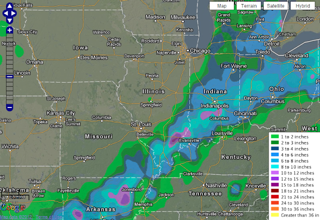
It's important to note the STEEP drop of snowfall totals away from the area sometimes referred to as the deformation zone.  The deformation zone is the area of diverging winds, cold air, and abundant moisture on the northwest side of a low pressure system where heavy wet snow occurs.  25 miles separated areas from 0 to 8in of snow.  That's an incredible snowfall drop-off.  The snowfall totals were diminished in the Effingham area by a slight shift of the storm system to the southeast.  You can observe the overall picture of snowfall totals below. 


Who's to blame?

Before you lynch your local meteorologist, consider the steep snowfall drop-off.  What about the opposite scenario?  What if we had received 6-10in of snow and the meteorologist forecasted a dusting or no snow?  He'd be wrong again right? Yeah, but in that circumstance people's lives would be at stake as city crews and schools would be unprepared.  So, a meteorologist will always side with caution to protect you and at times, save your life. 

The Sky Started it

When I awoke to no snowfall accumulation at 6am on Wednesday morning. I didn't curse my local meteorologist.  I cursed the sky. The one who's to blame. Weather is highly variable and rapidly changing, if you choose not to believe that, you're going to hate a lot of meteorologists in your lifetime. The meteorologist nailed this forecast. Minor details of a particular storm cannot be predicted with accuracy.  The public needs to understand the variability of weather and the fact that the tools do not exist to predict the future with 100% accuracy.  Weather is a game of probabilities, and sometimes you lose.

24 December 2012

Feast or Famine

What is perhaps the greatest uncertainty when forecasting snow in Southern Illinois is the temperature.  Will the temperature fall low enough to snow? Well, for once, the concern is not will it snow, but how much it will snow. It has been a rather long time since portions of Southern Illinois have seen a winter storm forecasted of this magnitude.  In fact, the National Weather Service in Paducah, KY has issued a rather rare Blizzard Watch for areas south of I-64 (featured in lime-green)

Winds are expected to be quite tame compared to what the area experienced last week (gusts reached 53+ mph as Blizzard conditions occurred from Springfield to northwest Illinois and Iowa).  Winds are expected to be from the north in the 25-30mph range and shift northwest as the area of low pressure passes to the southeast.  While, the winds will not be as fierce as last week, the winds are still strong enough to cause white-out conditions while traveling.

Deformation Zone

Perhaps what is of more interest are snowfall amounts.  It's what I often refer to as a feast or famine scenario. Areas located just northwest of the area of low pressure will experience snowfall totals not seen in a decade or more for portions of Southern Illinois.  However, this is a small area often referred to as the deformation zone.  Where gulf moisture, cold air, and diverging winds create incredible snowfall rates.


A small shift in the track of the winter storm can move the area of heaviest snowfall northwest or farther southeast.  Essentially, a small shift can drastically change the snowfall amounts seen in the Effingham area.  Recent forecast model runs show a southeast trend, which is bad news for snowfall totals in Effingham and areas northwest of Effingham.  However, we WILL see snow.  How much is the only factor at stake.


Snowfall Amounts

From this graphic, it's easy to see how a shift to the southeast can drastically hinder snowfall totals northwest of the area of low pressure.  As Springfield is only expected to receive half an inch.  If the trend continues, the snowfall rates in the Effingham area may be diminished. The National Weather Service in Lincoln, Illinois is still predicting rather modest snowfall rates for portions of southeast Illinois.  Including 5-6 inches for the Effingham area. 

Timing

Timing of the storm is always a variable.  However, it appears snow will begin to fall in our area around the 9pm mark and tapper off around 10am to noon on Wednesday.

Travel

Travel? Are you nuts?  Spend the late, white christmas with those who mean the most to you.  Take your favorite board game out of the cupboard, and force your family members to play it with you.  Even though you mop the floor with them on a yearly basis and laugh in their faces.  More importantly, don't forget the hot chocolate.  Merry Christmas Everyone.

02 October 2012


Weekend Wall Mounts


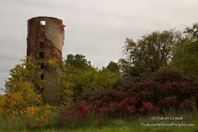
I stayed home for less than 24 hours, but snapped a few photos on my return to Macomb.  The above photo is an abandoned silo not far from my home near Stewardson, IL.


This is one of my favorite photos from 2012.  Though this may not say much to an average person, this speaks volumes for what many experienced this summer.  These strips of corn were left for insurance purposes, the rest of the field was silaged in early July.  The farmer never bothered to return for the strips.  The added rainfall has led to infestations of weeds and overgrowth in many of the fields in the area.  It's one of the few areas where the evidence of the drought is still apparent.  For me, the photo is very symbolic of life, following disaster.


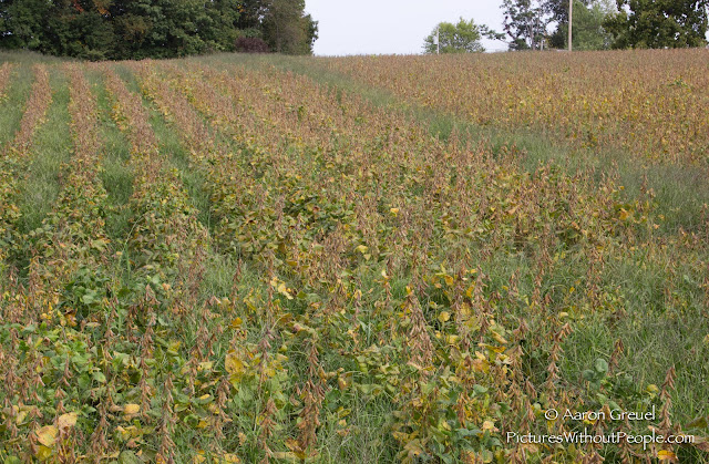
These beans have become overgrown by grass and weeds following above average precipitation for August and September near Green Creek, Illinois.  The soybeans have struggled to dry down due to a late reproductive stage, while the roundup sprays from the spring have had little effect on weeds this late in the year. 


Outside Springfield, IL I began to notice a partial rainbow.  It wasn't until I was well out of the town before I saw the halo and weak sundog.  Sundogs are an optical phenomena most common during winter months when the sun is low and when ice crystals are prevalent.  They form horizontal with the sun on sun halos.  Often sundogs are several times brighter, but cloud cover hindered this particular doggy. This photo was snapped just outside Petersburg, IL.

23 August 2012


Rain, 2 months late

The rain returns, the cameras shift, and those impacted continue to salvage what they can from one of the worst agricultural disasters in recent memory.  


Despite 5 inches of rain in August the damage is done, farmers continue to round bale their
corn in the Green Creek area (8/11/12)


The numbers are still pouring in from the drought, and the lasting impacts and significance have yet to be realized.  For some, the drought was bearable.  For many, the drought was historic.  For our location, it was the worst drought since 1936 according to several local "old-timers."  Using a neighbor's precipitation reports, I was able to confirm that we received 1.58in from May 1st-August 1st, which is 15.84in below average for our area.


The photo above was taken in Green Creek.  A farmer, rather than spend the time and fuel to round bale his corn, opted to unleash his hungry cattle on this corn field. 

While the drought was devastating in our area, the only area I've found in Illinois (I never traveled south of Effingham) that compares, if not trumps the Green Creek area, is an area between Havana - San Jose, Illinois on Route 136.  Farmers in this area take advantage of the Illinois River to irrigate their crops, but the fields without irrigation were absolutely horrendous.


The above photo was taken along route 136.  While I snapped this photo on August 17th, I traveled this route every two weeks.  This corn field had completely dried out by late July.  In addition, even the soybeans in this area (that lack irrigation) are dead or dying.


For those of you who are not familiar with the phenology of soybeans, they can take drought. They're survivors. To see entire fields of soybeans die....wow. 


I snapped this photo on August 17th of a farmer shelling his corn.  Due to the drought, harvest has begun a month early in this area east of Havana, IL.  During a normal year, the corn in this photo would be twice as tall (half way up the combine's cabin).

The growing season is nearly over, and the disaster will have less of an impact following the passage of summer.  I've taken over 500 photos of drought this summer.  I made a point to shoot whenever I had free time.  Not because it was "newsworthy," but because I knew that I may never see a drought of this magnitude again in my lifetime.  It was my attempt to document it.  I encourage you to get out and see these drought ridden areas.  You may not have another chance for another 20-30 years
(we hope).

09 August 2012


Rainshaft Wednesday


Near Royal, Illinois, I stumbled upon a simple paradise.  Gently rolling hills, an unheard of amount of old barns and abandoned homesteads, and an enormous wind farm under construction.  Absolutely libidinous landscape for those of you that enjoy the beauty of Illinois.   


A stationary boundary has camped over Illinois for a few days.  Though I was not expecting much yesterday, I was pleasantly surprised when I glanced at the radar around 4pm.  I had a 20 minute bike home from work and hit the road around 5:15pm.  

North of St. Joesph, Illinois, I stopped to take my first photo.  Set up my camera, turned it on, no SD card.  I can't say this is the first time I've committed such a blunder.  Fortunately,  I had an SD card in my camcorder.  Popped it in, flipped my camera back on, SD card is full.  Typical, I spend hours capturing images and video, but I don't bother to unload my stock.  I deleted a few of the undesirables, but combated my full memory card the entire trip.  As a result, I didn't snap a lot of "mediocre" shots.  I had to conserve my ammo. 


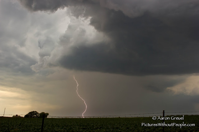
The photo above, was taken just east of the first photo.  I continued to follow this storm east through the unfinished wind farm for roughly 10 miles.  After I had these initial photos of the rainshaft, I attempted to capture a photo of the intense and frequent CG (cloud to ground) lightning.  I, of course, did not bring my shutter release cable and attempted to capture a shot while holding my camera on a mini tripod from inside my car.  


As I waited between impressive CG strikes, I couldn't help but ponder how my hobby increases the likelihood that I'll be struck by lightning.  For instance, in early June I was outside my car photographing an incoming storm, that was well off in the distance.  When a CG struck within a 150 yards of me, killing one of my father's cows.  So, I've been pretty uneasy about photographing outside of my car this summer.  While pondering my increased odds of an unceremonious death, I missed several great opportunities to photograph these incredible strikes.  I was able to capture the one above, east of the wind farm, in a stroke of luck. Without a shutter release cable, it's increasingly difficult to photograph these thunderstorm cuties.

At this time, I gave up my pursuit.  The thunderstorm moved east of me and combined with another t-storm to the south.  If you're photographing weather, always be aware of the sun's location.  When you're in-front/southeast of the storm, it illuminates features such as the rainshaft, wall cloud, and/or tornado.  In addition, I always like to move west of evening t-storms and use the sun for new perspectives.  Plus, you almost always observe a rainbow if there is minimal cloud cover on the other side of the storm.


The sun lit foreground and illuminated dark, blue sky.


Another shot with the sun to my back.  A smaller storm popped up behind the orignal storm and produced an impressive rainshaft.  It looks like a Pokemon creature moving across the sky, but interpretations may vary.


At this point, it was only a matter of time before a rainbow showed up.  This is the only shot I snapped of the rainbow, because not only was I out of memory space on my SD card, but it was incredibly peaceful to just observe the rainbow, lightning, rumbling thunder, and chirping crickets.  I sat on the hood of my car and just enjoyed the moment.  Even better, there were no cars or people in sight.


You may recognize this area, as this is where I captured my first photo of the day with an impressive rainshaft.  I decided to stop and photograph the sunset on the way home.


While you're here, I uploaded a photo album last week.  You'll find it under Photos and under Pre-2011.  In the album you'll find photos I captured long ago.  I'll continue to add to the album this weekend as I find/edit my ancient photographs.

30 July 2012


 Updated Photos

All photos from Sigel, IL area

Farmer raking his corn to round bale for hay.  Created his own personal dust cloud.
My backyard.  Several trees in our area are losing their leaves due to drought stress.
Our alfalfa field next to our farm.  Last harvested for hay the first week of June.
Three weeks ago, this was one of our best corn fields as it is located in a river bottom.  However, river bottoms provide poor, sandy soil, resulting in this corn drying up rather quickly when the moisture ran out.  Also, observe the trees browning in the background.
Green Creek and Henry Creek meet at this location and feed into the Little Wabash River.  These creeks and many rivers in our area have dried up entirely and turned into ATV highways.
The only soybeans that grew in this field, planted the second week of June.
Entire wooded area browning from moisture stress
Farmers leave strips in their field for insurance purposes.  Fields that lack strips, are owned by farmers who lack insurance.
A lone survivor.

If we do not receive rain tomorrow we'll end the month of July with 0.14in just shy of a local 100 year record.


10 July 2012

Farmers are like Squirrels

Drought, a farmer's worst nightmare:


Farmers suffer from every natural and man-made disaster, almost on a yearly basis.  Floods, extreme wind events, the economy, hail, and tornadoes.  But the threat that trumps all….drought.  In the aforementioned events, the damage is usually to a finite area, though painful, the farmer can still salvage most of this crop and break-even/make a profit.  Why is drought so devastating to the farmer?  It’s actually fairly easy to understand.  Drought affects every field, every inch of land, it affects every shade of grass, every stock of corn.  If the drought is severe enough, 
there is nothing to salvage.


A little about supply and demand:


Drought of course does more than destroy a farmer’s crop.  Drought also devastates farmers with livestock.  What do farm animals eat? Grass. Hay. Grain. Right..you’re good.   But no rain means there’s no grass, no hay, and no corn for grain, which means there’s no food.   So, if hay and grain exist for sale during a drought, guess what?  Large demand (because there’s no food), little supply (hardly anyone has any to sell) = hefty price.  But the farmer has no money to pay these ridiculous prices to feed his animals, so what does he do?  Sells his cows.  Problem is, every farmer is selling his cows.  So, all of a sudden you have a large supply of cows, but the demand isn’t changing, what happens to the price?  Bottoms out.  Farmers actually lose money selling their cows during a drought, as they had more money put into the cow (in grain, hay, and water) than they made selling the cow.  But, what choice did they have? 

Gathering nuts for winter:

Farmers are like squirrels.  Farmers spend a large part of the summer preparing for the winter.  Food for animals does not exist in the winter, so you need to store food to feed them over the winter in hay and silage (chopped up corn/alfalfa).  During drought years, in addition to losing your crop and the grass in the pastures to feed the animals, you lose all the food you need to prepare for the winter.  So, not only do you lack food for the livestock currently, but what are you going to do come winter?

Farmers are weak-minded sissies:

When drought is destroying your livelihood, it affects you emotionally and mentally.  Farming is 5am-9pm.  Every Sunday.  Every holiday.  Every birthday.  If you can imagine working 80+ hours a week for 6 months, only to see everything you’ve worked for, destroyed by something you can’t control.  Then you realize not only did you work your tush off for six months, but you’re also going to lose $200,000+ invested in your fields (which was invested in fertilizer, chemical sprays, and the seed itself).  You can imagine the emotional toll.

Torture does the body good:

Many people often agree that when taking off a band aid, the best way is rip it off fast.  It’s agonizing to rip it off slow.  Wind events, floods, tornadoes, hail, are all quick band aids.  You can argue floods, but usually they are over within a week.  Drought is a different kind of monster.  It’s a slow, agonizing torture.  Spanning entire seasons, and in some extreme cases, years.  It’s even more painful when those around you receive rain, while you receive nothing.  I’m not sure how a farmer goes about keeping his sanity, with so much riding on the uncontrollable weather.

I plan to continue to add new blog updates covering the drought in the coming week.  Hopefully with some colorful pictures next time.

06 July 2012

Drought

As many of you know, portions of Southeast Illinois are experiencing horrific drought conditions.  I plan to do a write up covering the drought in the next few weeks.  Till then, you can read about the drought through these websites.  Many of them have used some of my photos to cover the drought. 

05 July 2012

Website Construction

Hi there,

Thank you for visiting my webpage.  I am currently scripting, editing, and creating this website.  So, if links are broken or if pages don't work, they will be fixed and completed in time.  Don't be surprised to see things change on my site as I think of new ideas and discover new ways to use HTML code.  I will be posting recent updates, news, and photography accounts here on my main page when my website is fully launched in September.  Till then, you can monitor my progress and website creation. 

All the best, Aaron