Feast or Famine
What is perhaps the greatest uncertainty when forecasting snow in Southern Illinois is the temperature. Will the temperature fall low enough to snow? Well, for once, the concern is not will it snow, but how much it will snow. It has been a rather long time since portions of Southern Illinois have
seen a winter storm forecasted of this magnitude. In fact, the National
Weather Service in Paducah, KY has issued a rather rare Blizzard Watch for areas south of I-64 (featured in lime-green).
Winds are expected to be quite tame compared to what the area experienced last week (gusts reached 53+ mph as Blizzard conditions occurred from Springfield to northwest Illinois and Iowa). Winds are expected to be from the north in the 25-30mph range and shift northwest as the area of low pressure passes to the southeast. While, the winds will not be as fierce as last week, the winds are still strong enough to cause white-out conditions while traveling.
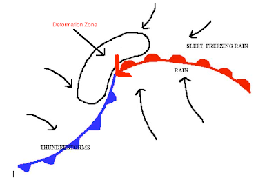
Deformation Zone
Perhaps what is of more interest are snowfall amounts. It's what I often refer to as a feast or famine scenario. Areas located just northwest of the area of low pressure will experience snowfall totals not seen in a decade or more for portions of Southern Illinois. However, this is a small area often referred to as the deformation zone. Where gulf moisture, cold air, and diverging winds create incredible snowfall rates.

A small shift in the track of the winter storm can move the area of heaviest snowfall northwest or farther southeast. Essentially, a small shift can drastically change the snowfall amounts seen in the Effingham area. Recent forecast model runs show a southeast trend, which is bad news for snowfall totals in Effingham and areas northwest of Effingham. However, we WILL see snow. How much is the only factor at stake.

A small shift in the track of the winter storm can move the area of heaviest snowfall northwest or farther southeast. Essentially, a small shift can drastically change the snowfall amounts seen in the Effingham area. Recent forecast model runs show a southeast trend, which is bad news for snowfall totals in Effingham and areas northwest of Effingham. However, we WILL see snow. How much is the only factor at stake.
Snowfall Amounts
From this graphic, it's easy to see how a shift to the southeast can drastically hinder snowfall totals northwest of the area of low pressure. As Springfield is only expected to receive half an inch. If the trend continues, the snowfall rates in the Effingham area may be diminished. The National Weather Service in Lincoln,
Illinois is still predicting rather modest snowfall rates for portions
of southeast Illinois. Including 5-6 inches for the Effingham area.
Timing
Timing of the storm is always a variable. However, it appears snow will begin to fall in our area around the 9pm mark and tapper off around 10am to noon on Wednesday.

